sanjibsworld.com
Home | My Page | Indian Missions Abroad | Foreign Missions In India | Schools In The U.S. | J-Schools In The U.S. | Canadian Media | Cool Links For Journalists!!! | North-East India | Arunachal Pradesh | Assam | Manipur | Meghalaya | Mizoram | Nagaland | Tripura | Rajasthan | India | It's All About HTML, Honey!!! | Study In Malaysia
Nagaland

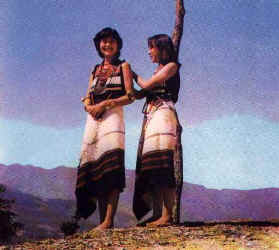
Naga girls

Nagaland at a Glance

Attained statehood in : 1st December, 1963
State Capital : Kohima
Bordering states / countries : East Myananmar and Arunachal Pradesh, West & North Assam, South Manipur
Longitude : 93.20 degree E to 95.15 degree E
Latitude: 25.6 degree N to 26.4 degree N
Administrative set up : Nagaland has 8 districts viz., Dimapur, Kohima, Mokokchung, Mon, Phek, Tuensang, Wokha, Zunheboto,
Major towns : Kohima, Dimapur, Chumukedima, Mokokchung, Tuli, Mon, Phek, Tuenchang, Wokha, Zunheboto
Area (in sq. km) : 16,579
% of forest cover : 21.60
Demography as per 1991 census :

Population
Total: 1209546
Male: 641282
Female: 568264

Literacy %
Total: 61.67
Male: 67.62
Female: 54.75

Projected population (by 2000 A. D.):

Population

Total: 1706000
Male: 887000
Female: 819000

Major crops : Rice, Maize, Wheat, Grams, Mustard, Cotton, Jute, Sugarcane
Major plantations : Rubber, Coffer, Tea
Fruits / vegetables / spices : Banana, Pineapple, Jackfruit, Potato, Sweet potato, Tapioca, Chillies, Ginger, Garlic
Major minerals : Coal, Limestone, Petroleum, Slate
Industrial estates : 4
Industrial Growth Centres : 6
Ten largest projects :

Sl. No. Investment (Rs. in Crore)

I N.E. Electric Power Hydro-power 384.75
II State Electricity Deptt. Hydro-power 127.00
III Power Grid Corp Transmission 121.62
IV Reliance Telecom Cellular phones 50.00
V Ministry of transport Roadways 38.00
VI State Electricity Deptt. Hydro-power 33.84
VII National Airports Authority Airport 34.00
VIII Govt. of Nagaland Medical services 25.00
IX Govt. of Nagaland Environment protection 13.00
X Govt. of Nagaland Industrial research 10.00

Source: Business Today (22 Dec.97 to 6 Jan. 98)

Educational institutes :

Type Numbers
University 1
Colleges 40
Higher Secondary School 4
High School 236
Middle School 418
Primary School 1399
Polythchniques 2
Industrial Training Institutes 5

No. of banks branches : 94
No. of post offices : 307
Railway route length : 12.85 kms
National Highways length : 365.38 kms
State Highways length : 1094.60 kms
Airports : Dimapur
Per capita income during 1996-97 at current prices : Rs.11368
Language : Nagamese, English, Hindi & local dialects
Power generated (1997-98) : 8.33 MU

Strengths :

Active village development board/ council
98% of villages electrified
Hill slopes ideal for plantation of cash crops
Oil and gas deposit
Scope for tourism
Scope for expansion of border trade with Myanmar at Lungwa
Good prospects for development of handloom sector

A hanging bridge over a rivulet near Dimapur in Nagaland

For foreigners visiting Nagaland: Download RAP (Restricted Area Permit) form here (PDF format)

Download Adobe Acrobat Reader to read/print .PDF files

Nagaland Tourism
Nagaland is one of the border states in the North East with a common boundary with Myanmar on the East. It is a land of un-imaginable beauty with exquisitely picturesque landscapes, vibrantly colourful sunrise and sunset and lush and verdant flora. Nagaland is blessed with salubrious climate throughout the year and provides the right ambience for a tension free life. For the adventurous and the intrepid, Nagaland is an ideal place for trekking, rock climbing, jungle camping etc. It is covered with luxuriant vegetation and enriched by the cultural heritage of sixteen odd tribes and sub-tribes. The people of the state have a penchant for dances and festivals and they greet each other with colourful traditional costumes, lively folk songs and vigorous dances during festivals. The capital city, Kohima, is a hill station and has a war cemetery with 1200 bronze epitaphs placed in neat rows in memory of the brave soldiers. The major tourist centres in the state and their attractions are as given below:

Major tourist centres in Nagaland

Name of the place
District
Main attractions

Dimapur
Kohima
Kachari Monuments, Seithekima waterfalls, Chumukedima village and waterfalls, Intangki wildlife sanctuary, North East Zone Cultural Centre, Handloom and Handicrafts.

Kohima
Kohima
War cemetery, State museum, Zoological park, Cultural centre, Catholic Cathedral, Kohima & Khonoma village.

Dzukeu Valley
Kohima
Unique flora like white and yellow lillies and white rhododendrons, good trekking spots.

Dzulikie
Kohima
Scenic beauty, Dzulekie river.

Japfu Peak
Kohima
Hill resort, good trekking and scaling spots

Kokokchung
Mokokchung
Cultural centre of Ao Nagas, Scenic beauty, White waters of Milak and Tzula rivers with potential for rafting and angling, Ungma and Langpangkong and Longkhum villages and Mongzu ki eagle's eyrie.

Mon
Mon
Home of Konyaks who have tattooed faces wearing feathered headgears and traditional dresses. They are also adept artisans and skilled craftsmen.

Phek
Phek
Colourful Orchids, Chizami Baptist Church, Khezakenoma village and Shilloi lake.

Tuensang
Tuensang
Unique cultural heritage of 5 tribes & built on several hillocks, highest peak of Saramati and the Pungro peak, good for trekking.

Wokha
Wokha
Mount Tiyi and Totsu with potential for trekking and rock climbing, known for scenic beauty and local folklore, Liphanyan Governor's Camp is an ideal spot for rafting, angling and river camping.

Zunheboto
Zunheboto
Beautiful landscapes spread out on clusters of hillocks, Satoi range of virgin forests, Ghosu bird sanctuary.

.

Hornbill Festival, Kohima, Dec. 2002
A Naga boy in traditional attire holding an antique gun

Enter content here

-